Buzze A. Long’s New Route 66 Logo
Buzze A. Long’s New Route 66 Logo
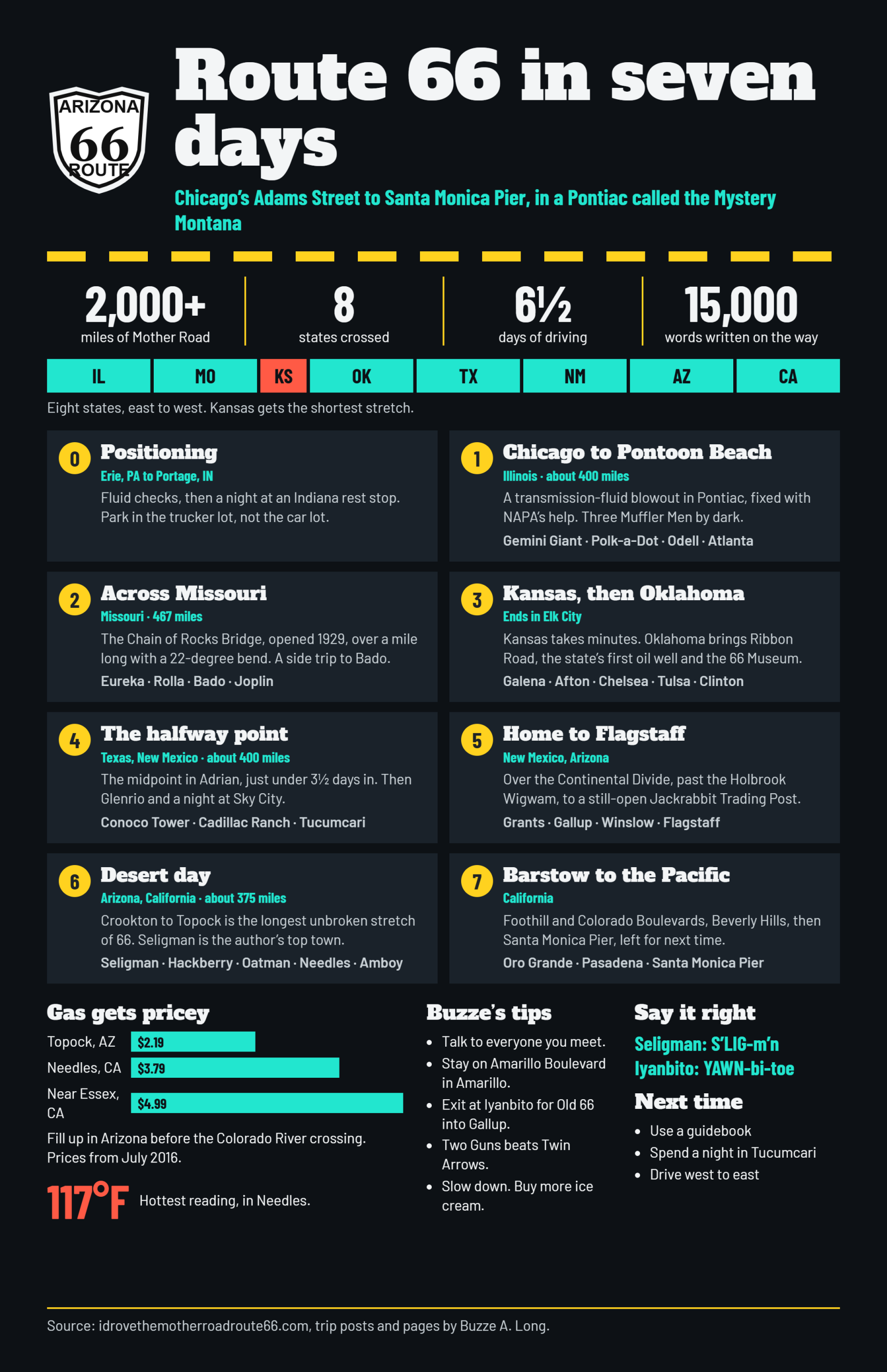
Buzze A. Long’s New Route 66 InfoGraphic Explainer
Last Updated October 25, 2026.
Your travel reporter Buzze A. Long was up before the sun and drive across #Route66 to America’s Most Advertised Fast Food Joint ™
in Barstow, California.

Get Your Kicks on Route 66. Buzze A. Long Visits the Santa Monica Pier.
In Barstow, the fast food shares billing with Barstow Station. Keeping my no-junk-food pledge from yesterday, I buy only a hot tea and open the laptop to update yesterday’s Day Six on America’s Main Street.
I am able to get most of yesterday’s post up without getting kicked off the WiFi or losing the post. It’s a great day to be Buzze A. Long.
Dawdling over the hot tea, I’ve waited for the traffic in LA to be somewhat less crazy. It’s time to be on Route 66, America’s Main Street again. Time to

The US Route 66 Shield, Barstow, California
Filling up the empty hot tea cup with Dr. Pepper, I head out the door. One thing I’ve learned on this trip is that more often than not, refills on hot tea are refused so I’ve adapted.
Out in the parking lot I watch as a guy comes out on the balcony of Barstow Station to have a cigarette. I’m in the parking lot having bananas. Not smoking them, having them for breakfast. We’re even, but probably my breakfast is healthier than his.

Going Bananas For Breakfast At Barstow, CA
I make a right out of Barstow Station and drive West on The Main Street of America. There is little traffic this morning in Barstow, plenty of time for pix. The markings for Route 66 have been good through this part of The Golden State.
Immediately upon entering California, Route 66 / I-40 travelers enter San Bernadino County. The County has taken an interest in America’s Main Street, relabeling it as CR 66. This makes it pretty easy to follow Route 66 across the empty expanse of eastern California.
Here in Barstow, the Route 66 shield is augmented with the state name. I circle a block once to get some pictures, then drive west out of town. Like a lot of #Route66 towns, Barstow is long and skinny.

Route 66 Road Sign In Barstow, CA Includes The Word ‘California’

Route 66 Shield Is Painted on The Surface of The Mother Road in Barstow, California

Here Route 66 The Mother Road Is The Strip West Out of Barstow, CA
Leaving Barstow behind, The Mother Road bends gradually southward toward Oro Grande.
North of Oro Grande there is a wide spot in the road called “The Iron Hog”. I stop to get some pix and find that the Mojave River Yacht Club is active in this area. I sure hope the Mojave rises enough that they get some sailing in this year. The Stars and Stripes are flying at Iron Hog. God Bless ‘Em.

South of Barstow, CA The Wind Blows over The Mother Road, Route 66

The Mojave River Yacht Club Meets At The Iron Hog, Oro Grande, CA on Route 66

It’s A Tattered Old Flag At The Iron Hog On Route 66, Oro Grande, CA
Oro Grande is coming into view now. It is just north of Victorville. There is an airport off to the right.

Mohawk Gas Station On Route 66, The Mother Road

Have A Cow In Oro Grande, CA

San Bernadino County Marks US Route 66 As CR 66
Prior to getting on I-15 south, I stop at a gas station to use the restroom. Don’t want to be crossing my legs in the upcoming L.A. traffic. I’m first in line. There are 2 bathrooms for guys but both are locked. One is marked ‘Customers Only’. Honestly, I’d be a customer if I needed something. Any port in a storm. Five minutes later, the line is growing, both doors have been knocked & shaken but no go. No go for me either.
I decide to hold it and run into Victorville. Outside, my resolve weakens. Traffic be damned, I’ll skip Victorville & hold on as long as I can.
The entry to I-15 is uphill. Traffic is in front of me on the on-ramp. Slow traffic. ASAP, I move left across a couple of lanes to get past the slow traffic. Out-of-state plates, across 2 lanes at less than cruising speed and I fail to attract even one horn blast.
I’m gonna like L.A.

This Exit on The Mother Road Is Named For Victorville, California’s Notorious Gunslinger
I-15 inclines upward for a while, then we’re above 4,000 feet elevation. Over the top, then we’re on a downhill. There are signs warning to watch your downhill speed. Trucks are limited to 45 but they don’t seem to notice the signs.
About halfway down the hill, there is a sign indicating Old Route 66 travelers should exit, stage right. I pull off and am in another world. Beautiful scenery, sparse traffic. Once off the freeway, you can go either way and Route 66 is not marked. I decide to
as it parallels I-15, even though the opposite direction would appear to head West.
It’s the right call. What a peaceful drive down the canyon, first 2-lane then 4. I get a few pictures and wonder what this road was like when Clark Gable and Carole Lombard made the trip east. Probably, it was in a different canyon. 😉
Further down the canyon, the four-lanes are marked ‘ROAD CLOSED’. A quick stop to get some pix of the train way down there in the canyon, then back on I-15.

Old Route 66 West From I-40 Near Wrightwood, CA

Train Near Route 66 Re-entry to I-40 Near Wrightwood, CA
Either I missed it or Surprise! There seems to be no way back onto I-15 South from this entry. I follow the road and wind up on I-215. No biggie, I just go a ways on 215, then do a u-ey and head back east. Look, they put the Devore exit on I-215 just for me.

Devore Exit Eastbound on I-15 Leads to Route 66, The Main Street of America
Off at Devore, but no clear direction on which way to go. Here is where some training in a previous life came into play. Long ago and not so far away, I spent some time driving on the Navajo Rez. Some of the places I traveled were so far back into the Rez, I’m sure I could have gotten a Rez dog lost. After the monsoon, quite often not only had the original road washed away, there were 3 new ones to take its place. All of them took off in different directions and of course had no signage, signs being rare on the Rez.
After a few years on the Rez, the Bilagaana becomes part Navajo. You learn to navigate by some innate ability, almost as though you can smell your way around.
I sniff, bear left and am rewarded shortly with the shield. It’s a double-header.

Bear Left After Getting Off Devore Exit To Stay On Route 66
The guys from BNSF are out riding the rails as I follow the gradual slope downhill toward the

Checking The BNSF Tracks Along Route 66 in San Bernadino, CA on #IDroveTheMotherRoadRoute66.com
Trivia Question: What famous entertainer lost an eye when his Caddy wrecked near San Bernadino?
I don’t have a gigantic street map of the L.A. area but Rand McNally from Wally World seems to favor a left onto Mt. Vernon. Once again, it is the right move on this gorgeous summer morning.

Take This Left On Mt. Vernon To Remain On Route 66, The Mother Road in San Bernadino, CA

Route 66 Highway Sign Marking in San Bernadino, CA
This area is a little old-fashioned, like the ’40s or ’50s. Maybe a little run-down, but just pleasantly so. I keep expecting one of those hard-boiled characters from a Raymond Chandler novel to drive by.
I see a few brown
in San Bernadino but then get suspicious that I’ve overdriven it. I know I’m looking for a right on Foothill, so I drive a few blocks West, then head north. Here it is, Foothill Blvd. I will follow this West until near Pasadena.
I crossed Rancho while traveling south on Mt. Vernon. I think ‘Rancho’ is the name of Foothill as it enters San Bernadino. Next time, I’ll know.
Just West of San B.,
is celebrating The Mother Road. Notice they have branded the Route 66 brown shield:

Rialto, CA Loves The Mother Road Route 66
Following The Main Street of America is pretty easy here on Foothill Blvd. Not only is it straight through, but most communities along The Mother Road have installed center island dividers with distinctive markings and landscaping unique to each town. Just follow
pretty much all the way to Pasadena.
has installed some great-looking monuments and landscaping in the island:

Fontana, CA Route 66 Markings in Center Island of The Mother Road
As I looked at the L.A. map earlier, I dreaded traveling along Foothill, thinking the traffic may be hectic. It’s exactly the opposite, laid back and traffic is relatively light. The only challenge I encountered was time. Driving The Mother Road across the northern L.A. suburbs took a few hours, but otherwise an interesting, scenic and relaxing drive.
Rancho Cucamonga not only marked
in the center island but also installed brick paving strips periodically, emblazoned with the ’66’ shield.

Marking The Mother Road in Rancho Cucamonga, CA – Monument in Center Island of Route 66

The Main Street Of America Is Also Marked By Brick Pavements In Rancho Cucamonga, CA
Near Upland, I passed under a bridge celebrating the history of

Near Upland, CA Route 66, America’s Main Street Passes Under A Hot Rod Bridge
installed some unique markings in the center. Have you noticed that each city has planted unique type of plants in order to differentiate itself from neighboring towns?

Welcome to Claremont, CA on #IDroveTheMotherRoadRoute66.com
This is just cruising on Foothill, pretty good progress with occasional stops for lights.
Welcome to

San Dimas, CA Welcomes Route 66, America’s Main Street
And then on to
the town with everything from A to Z in the U.S.A.

Azusa, CA Welcomes Route 66, America’s Main Street

Azusa, CA Has Its Own Center Island Style on Route 66

Bear Left To Remain on Route 66, America’s Main Street, at The Foothill Drive-In Theater, Azusa, CA
uses its center island to honor those in the Military.

The Center Island of The Mother Road, Route 66, Monrovia, CA Salutes The Military
I leisurely pass through

Route 66 Passes Under This Bridge In Arcadia, CA
then on by

Rt 66 Passes Through Santa Anita, CA
Just west of here, the road forked. Colorado Boulevard is the right fork, the one to use for The Mother Road. I mistakenly go straight and am temporarily off 66. Realizing my mistake, I go around a shopping center, the racetrack and re-join Colorado Blvd a little later.
I look around for the Little Old Lady in Her Shiny Red Super Stock Dodge, but alas, no drag race today. The Terror Of Colorado Boulevard must be home, taking a nap.

In East Pasadena, I Got Back On Colorado Boulevard, As Route 66 is Known Here

East of Downtown Pasadena, CA
is pretty much the end of street road driving until Santa Monica Boulevard in West Hollywood. In Pasadena, I pick up Arroyo south ( CA 110 ) and head toward Downtown L.A.

Following Arroyo South
I then pick up the Hollywood Freeway, the 101, toward Ventura and follow it to the exit for Santa Monica Boulevard.

NW on The 101 Toward Santa Monica

The Santa Monica Blvd Exit off The Hollywood Freeway

At Santa Monica Boulevard, Turn left Toward West Hollywood
Safely back on a street road, Santa Monica Boulevard, I enjoy the drive west toward Beverly Hills. Just a few miles and I’ll be in the City of Santa Monica.

Speed Is Checked By Radar All Over California For My Safety. Thanks Guys, But In Front Of A Dispensary? How Fast Are THOSE Guys Flying?
Since getting off the 101 I’ve been driving Route 66 in
Traffic is OK. It isn’t that everyone in the western half of the U.S. is headed to the beach at Santa Monica Pier. They are already there, as I will discover later.

Route 66 in West Hollywood – Santa Monica Blvd at Formosa

West Hollywood – Center Island On The Mother Road

Dan Tana’s Restaurant Along Route 66
West of West Hollywood lies a place that many people, including Jed Clampett, have aspired to reach:

Old Glory Flies Over Beverly Hills

Corner of Rodeo Drive and Santa Monica in Beverly Hills, CA
With a double roar, the lanes split in Beverly Hills! Just like Moses and the Red Sea!

Lane Splitting in Beverly Hills, U.S. of A.
Moses may not be here but the Tourists are worshiping at the Altar of Beverly Hills!

Tourists At The Beverly Hills Sign
As I drive westward toward the Pacific Ocean, I notice a familiar face.

Ronald, We’re Almost There – Don’t Sit Down Yet!
Then I’m in
I don’t know if I even noticed the sign …
I take a left on Lincoln as the GPS guides me south to Pico. Colorado Boulevard is NOT a through street to the Pier, so I’m guided south, west and back north toward the Pier.

Lincoln Crosses Route 66 at 90 Degrees
A right on Ocean and I’ve looped around to the Object Of My Seven Days of Travel!
At Last! Santa Monica Pier on The Pacific

Another Shot of The Santa Monica Pier
I did not stop at the Pier. I had to leave something undone for next time, when ol’ Buzze will do the entire Road Trip On Route 66 again, but in reverse:

Ocean Blvd Looking North at Santa Monica, Just North of The Pier. Turn Right on Santa Monica to Go Home!
In six-and-a-half days I’ve traversed most of the continent, traveled many miles, eaten too much fast food, too much good food, took a million pictures, written 15,000 words, had a lot of great experiences and built a lot of great memories which will be x2 on the reverse trip!
I Drove The Mother Road Route 66!
See you on the flip-flop!
Meanwhile, it’s home to Arizona for some R&R, fleshing out the blog and ensuring things are OK at the house!
Buzze A. Long, reporting from the Santa Monica Pier, Santa Monica, California!
I’ll be updating the site with a scorecard, many more pages about locations along the way and reflections & roundups!
Thanks for reading and following along!
Yesterday on America’s Main Street, The Mother Road
#IDroveTheMotherRoadRoute66
Last Updated: October 25, 2026.
#Route66 is waiting. Your U.S. Route 66 correspondent Buzze A. Long was up early, the laundry is spinning and the gate of the secret compound is unlocked. As I pack up the Mystery Montana, I’m reminded of all the good times I had while living in Flagstaff, Arizona.
Monsoon came a little early this year in Flagstaff. Usually coming on July 4, it’s been raining on and off for the past few weeks.The monsoon season in Flagstaff is beautiful. The sky is a brilliant blue, as it is this morning. About noon, the sky clouds up, a little or a lot, then the rain falls. It might fall on you or you may see it 30 miles away, breathing life into the desert.
The Family Breakfast includes blueberry muffins and fresh fruit. Goodbyes are said, then the Pontiac Palace comes to life.
I follow old Route 66 through Flagstaff, make a right at B&N then pass the Galaxy Diner.
closer to the AT & SF, then left onto I-40.
Camp Navajo is on the left as I exit I-40 at
Taking a right, then a left, I follow Route 66 westward just north of I-40. The hard road soon turns to dirt. Should I turn around? No, I just slow down and enjoy the scenery.

Route 66 Gets Dirty West of Bellemont, AZ

Route 66 Travels Past A Ranch Near Williams, AZ
This area of Route 66 is Open Range. For you tenderfeet, this means that there is no fence to restrain livestock from entering the road. I am following the Beale Wagon Road through this section of The Copper State.

Open Range Route 66 East of Williams, AZ
Driving over alternate gravel and old concrete West out of Bellemont, I’m reminded that my Grandpap Beatty and Uncle Jim had traveled to Williams on The Mother Road back in the ’40s or ’50s. Grandpap had moved to the east in the early ’40s and had always dreamed of returning to the West.
East of Williams, I’m driving the same dirt and concrete they drove so long ago. It makes me feel grounded, content, at home.
Bill Williams Mountain is a unique and familiar shape off to the left of Route 66, guiding me toward his namesake city.

Bill Williams Mountain and Livestock – A Picture of The Real West. Bill Williams Is Furthest In The Picture, On The Horizon
It’s a peaceful drive through the Ponderosa Pines toward Williams. The City Limit sign for Williams comes while I’m still in the tall pines:

Williams.AZ City Limits On #IDroveTheMotherRoadRoute66
The Mother Road does not continue into Williams; nowhere to go but back on I-40 West for about a mile to the Williams exit.
Under the bridge and pop over the hill into
The road splits on the east end of town. The parked cop car is on the right as I enter. It has a twin on the west end of Williams.

The Stationary Cop Car in Williams, AZ
I notice that Pancho McGillicuddy’s is gone. No surprise. The food was good but the place was rarely busy, at least at lunchtime.
Williams, like Winslow, is coming back due to 66ers on The Mother Road. It’s a mix of old & new; old buildings with new businesses selling new merchandise celebrating an old idea: Route 66.
Williams will probably get its own page here on the blog.
Back in The Old Days when I worked in this area, I came into Williams for lunch. Feeling a bit playful, I sat down beside this old codger and started moving my arm in unison with his. A few minutes later, a Tourist Gal came down the street and nearly sat in my lap. “Oh, excuse me”, she said, “I thought you were a dummy”. Her loss, not mine.
A few pix along Route 66….

An Old Codger in Williams, AZ

Williams, AZ Was The Last Route 66 Town To Be Bypassed by I-40

A Reminder That Freedom Is Not Free in Williams, AZ
and I’m back on the ‘Slab toward
I know this because it’s on their Welcome Sign.

Ash Fork, Arizona Is The Flagstone Capital by #IDroveTheMotherRoadRoute66
I’ve eaten here once or twice before in my travels when I worked in this area. The years have not been kind to Ash Fork. There is at least one new business, a restaurant/bar on the east end, in a new building no less. C’mon back, Ash Fork.

DeSoto in The West End of Ash Fork, AZ – US Route 66
I make a left at the west end of town, loop through the eastbound street, back west again. As I take a picture in town a car horn erupts. It’s not just a ‘beep’, it’s a long blast, 10 seconds. A small car with peeling paint and an angry driver. Right here in Ash Fork! I look at it carefully, trying to decipher why anyone would lean on the horn so long in this peaceful little town. Later in the day Karma will catch up with this guy – keep reading!
As I look toward the passenger seat, the thought hits me: blueberry muffins, johhnycake, tomatoes, bananas, apples – there’s no reason to eat any junk food on this leg of the trip!
Tune in tomorrow to see if I can make it to Santa Monica, then home, without hitting a fast food place.
I say goodbye to the Flagstone Capital via a left onto I-40 toward the exit at Crookton Road. I take the exit almost automatically, having driven this route many times.
is marked with a painted shield after the cattle grate:

Route 66 Crookton Exit On The Mother Road Looking West Toward Seligman
to Topock is the longest uninterrupted stretch of The Mother Road. It says so on the sign at Topock. I’ve driven Route 66 from Crookton to Kingman on my motorcycle, years ago with Tall Paul from Back East, back in ’07. This time, I’ll add the distance to Topock.
As I drive west on Route 66 I get some good advice:
If Huggin’
Is Your Favorite Sport
Trade In Your Car
For a Davenport
Burma Shave (r)
I’ll have to remember that. Later in the day, I’ll pass a row of signs admonishing:
If Daisies Are
Your Favorite Flower
Keep Pushing Up
Your Miles Per Hour.
The area around Seligman has the densest concentration of Burma Shave signs on The Mother Road.
Since eastern New Mexico, or maybe Texas, The Mother Road has followed the AT &SF Railroad. I cross over it at the Historic And World-Renowned Crookton Overpass ™

Crookton Overpass Near Seligman, AZ
and continue toward my next date with destiny: S’LIGm’n.
The unique shape of Mount Floyd is off to the north. I ease on down the grade, stop, turn to the left and there it is. Seligman almost faded away. It is not fading now. At least 3 tour buses, one of them marked “Rocky Mountain”, are parked on the south side of Seligman’s Main Drag.

Seligman. AZ Is On The Tour Bus Route 66
is a big place. It’s growing, in fact it has been divided into two political entities: East Seligman and West Seligman.

Beautiful Historic East Seligman, Arizona

Beautiful Historic West Seligman, Arizona
In fact, it’s the West’s answer to the Twin Cities.
I park, get out and stroll about town. What a beautiful morning to be in S’LIGm’n – the sun is out and the town is lively. Zillions of people are here, many unfamiliar languages on the streets of Seligman. On the west end, there are even some obligatory Japanese tourists with obligatory Japanese cameras taking pictures that will be obligatorily shared after the obligatory return to Japan.
People come to S’LIGm’n from all over the world. Spend your money here in the U.S. of A.

Seligman, AZ IS Open For Business

Santa, I’ve Been A Good Boy – How About Some Delgadillo’s ICE CREAM For Christmas!

My Uncle Harvey Had a Packard Like This One in S’LIGm’n, Arizona

Dishwashing, Laundering, Bathing and Sleeping in Restroom Prohibited. So what good is it?

Seligman, AZ The Heart of It All on Route 66

I Elected Not To Stay Here …

Buzze A. Long Leaves His Mark in Seligman, Arizona
There were so many photo-ops, I’ll be giving Seligman its own page.
Back on The Mother Road, America’s Main Street, toward the West. I had forgotten that Mesa Country lies to the West of Seligman.

Mesa Country Lies West of Seligman, AZ
Of all the
#IDroveTheMotherRoadRoute66.com recommends Seligman, AZ above all others. Ol’ Buzze A. Long says “Don’t miss it”.
The miles unwind. This stretch of The Main Street of America, Route 66, must be 10 miles long, with nary a turn of the steering wheel. The Mother Road is ‘way out there on the horizon.

Route 66 Goes On For Miles In Straight Line
Then as soon as I pop over the ridge, another straight stretch. Not much wear on the tie rod ends here in The Old West.
I’m on a rez now. The highway drops down the valley into
I stop in Peach Springs, get a few photos

Peach Springs, AZ Building 1

Another Building In Peach Springs, AZ
and Keep Truckin’ On toward

Truxton Station in Beautiful And Historic Truxton, Arizona
The roadside signs have been warning that I’m getting close to
Hackberry, Arizona is famous, although I forget exactly what for.
I see they’ve put the Welcome Tank out.

Welcome Tank in Hackberry, AZ
Hackberry is also into alternative energy.

Windmills and Barbed Wire in Hackberry, Arizona
I’ve been cooped up in the Coupe since Seligman, so I get out and look around. Hackberry is a Neighborhood Watch Community, so I’m careful where I wander around.

Hackberry, AZ Is A Neighborhood Watch Community
I run into one of the many Silent Watchers:

Keeping An Eye on You in Hackberry, AZ by Buzze A. Long
Inside the General Store it is cool. Plenty of souvenir stuff inside, but I’m looking for sustenance. I find it in the back, in a cooler – ICE CREAM on a stick on Route 66. I make my purchase and move back outside.

Ice Cream On A Stick in Hackberry, AZ on US Route 66
A couple of old guys from California come in on Beemer bikes set up for long distance travel. The logo on the back indicates they are Iron Butts.
A few more Hackberry, AZ pix

Sheriff’s Car in Front of Hackberry General Store, AZ

Buzze A. Long Got Really Pumped Up About Hackberry, Arizona
Although Hackberry is just one store, I enjoyed it. I had so many pix, I’ll be giving Hackberry its own page soon. To me, it is second only to Seligman on The Mother Road.
Well, time to leave Downtown Hackberry.
I get back on The Mother Road and head West toward
Like most #Route66 towns in the far West, Kingman stretches out along The Main Street of America.
Kingman also has the Welcome Tank out.

The Welcome Tank Is Out in Kingman, AZ
Passing under I-40, I move along Andy Devine Avenue which is the local name for Route 66.

Andy Devine is Route 66, The Mother Road, Through Kingman, AZ
I follow US Route 66 west out of town as it parallels I-40, cross I-40, then make a left.
West of Kingman, The Mother Road, Route 66, becomes a Back Country Byway.

Route 66 Is A Back Country Byway West of Kingman, AZ by Buzze A. Long
The grade is flat, even downward in places, then begins to climb toward Cool Springs.

Getting Pumped In Cool Springs, AZ
Whoever named this place may have had a sense of humor, the car thermometer is indicating about 107 degrees F. The Mother Road’s most treacherous stretch lies west of here.
The road gets more interesting west of Cool Springs as I drop down into a little valley to Ed’s Camp.

Beautiful Historic Ed’s Camp, Arizona
There are many curves and switchbacks on the way to
Just to the west of the pass is a pulloff leading to an area where the cremains of the deceased are scattered. Why here? I don’t know, except the constant supply of wind? Keith Richards wouldn’t like that. You will also see paintings here. Old Glory flies at the pulloff.

Sitgreaves Pass Cremains Repository

Old Glory, the US Flag, Flies at Sitgreaves Pass, AZ

Paintings at Sitgreaves Pass
The Mother Road continues down the valley

Descending West on Sitgreaves Pass
to
located on Route 66 at 2700 feet above sea level. I stopped to get a pic of the welcome sign

Historic Oatman, AZ Welcome Sign
but otherwise did not stop in town. There were just asses hanging around, anyway.

A Couple of Asses in Oatman, AZ
What Hollywood power couple reportedly spent their honeymoon in Oatman?
As I drive west through the suburbs of Oatman,

Oatman, AZ Is Growing. Here Are the Western Suburbs.
a quote from The Father of Our Country appeared:

George Washington Quote, Oatman, AZ
“Government is like a fire – useful in the fireplace but if it gets out of its place it will consume everything you own”. Good quote, but it may have been embellished.
As I drive along The Mother Road toward Topock, I am reminded of this area’s volcanic origins.

Lava Near Oatman and Topock, AZ
If you are still wondering about Karma, about this time a car caught up to me and passed. The car is a little box with peeling paint. It was the horn-honker from back in Ash Fork. Whoosh! and he is around me. He travels along ahead of me for a while, then a blue cloud erupts from under his hood. It’s a harsh reminder that what goes around, comes around. He sits on the berm as I go by.
I drove along looking for
I wanted to gas up before leaving Arizona, as I recalled from a previous trip that prices in California were much higher. I was so intent upon finding Topock that I drove right through, or past, it without noticing and out the other side, passing
along the way.

Catfish Paradise, Arizona – Is It Paradise for the Fish Or The Fishermen?
There was an area here that had flooded recently.

The Road Had Previously Been Flooded and Covered With Mud
Although it is hard to tell from this picture, large piles of mud were piled head-high on both sides of the road, indicating that US Route 66 had been covered in mud recently. When I arrived home in Arizona, I would find that this same storm had created some havoc at my house.
Thinking Topock to still be ahead, I drove all the way to the Colorado River before giving up.

Topock, AZ – Speedboats On The Colorado River
Notice the “Welcome To Topock” sign in the picture above. Here, the Place Of Color River is anything but muddy.
A quick pic of the “Longest Stretch” sign

Topock to Crookton, AZ Is The Longest Unbroken Stretch of The Mother Road Route 66
then I hit the GPS looking for gas. It’s 3 miles away, back in Topock. So I did a u-ey and gassed up at $2.19 before heading to Californ-I-A.
Back at the Colorado River, I jumped on I-40 and crossed over into the Golden State.

Colorado River Crossing on I-40 Topock, AZ
The sign on the first CA exit indicates Route 66. I take it and wind West, but only until it weaves over I-40 because it turns to very primitive road. I turn around and follow it the other way, back to the Colorado. This piece of #Route66 is isolated by the river on the east and desert on the West. Perhaps you could take it west if in a 4WD, but it’s not for me. I got back on I-40 and headed about 15 miles up the road to
Taking the exit off I-40, I roll into Needles. First thing I notice is that, man, am I glad I gassed up back in AZ! $3.79! A buck-sixty more than Topock! What a difference a few Route 66 miles makes.

Needles, CA Gas Prices July 2016
As I drive through Needles,

Needles, CA Sign – Where’s the “Welcome”?

You Can Trust Your Car To The Man Who Wears The Star in Needles, California
I notice the temperature. This will be the highest temperature encountered on the trip, 117 degrees F.

117 Degrees in Needles, CA On July 5, 2016
Near Needles is a sign indicating the

Route 66, The Mother Road, California Gateway
At the same site is a sign reminding me that this is smack dab in the middle of the Mojave Desert.

Needles, CA Is The Heart of The Mojave Desert
At this stop, I receive a sign:

Signpost Near Needles. Many Miles Traveled, Many Miles Yet To Go. Oh Boy! Amboy Only 85 Miles!
About this time, I leave I-40 for US95 toward Vegas based on the Route 66 shield telling me to exit. I pull over to look at the map, still wondering if this is the right way to be traveling. I decide to risk it by going a few miles further and am rewarded with a sign indicating that a left turn would take me to Goffs, CA.
Those traveling between Needles and Ludlow via
should heed this advice: this is the most desolate stretch of highway while driving The Mother Road. Make sure you have plenty of gas and water.
After traveling through miles of desert, I blinked as I went through
and almost missed it. This is what it looks like as seen from the west end.

Goffs, CA As Seen From The West – Don’t Blink When Passing Through!
As I drove on, I noticed that Goffs must be growing, as the train signaling station is called “WEST Goffs”.
As I passed under I-40 prior to Essex, I notice that gas is $4.99 for Regular. Wow!
is on the horizon now. As I drive into town, the sign indicates that I’m still on #Route66, which has been following the National Old Trails Highway for some time now:

Essex, California Is On Old Route 66 Which At This Point Is Following The National Old Trails Highway

Beautiful And Historic Downtown Essex, California

The Western Suburbs of Essex. CA
Through Essex on Route 66 and out the other side, I notice a sign that looks sort of like a submarine near

Cadiz Restaurant, Cadiz, CA
As I get closer, I see that it is a restaurant that has fallen on hard times. I can see for miles in all directions and there are only a few buildings, most of them just specks in the distance. As I’m looking around I wonder about why this restaurant was built. Now of course, things have probably disappeared since then and people in the middle of the desert probably do get hungry. At the same time, once the restaurant was up and running, where were the employees going to come from? They guy must have had a large family and worked them in shifts.
As the shadows lengthen,
comes into view. Amboy Crater is to the south, but Hot Dog!, Roy’s is right along Route 66.

The Fabulous Hot Dog At Fabulous Roy’s on Route 66 in Amboy, CA
The Mother Road winds its way across the desert to

An Old Gas Station in Ludlow, CA
where I cross under I-40 and get on it headed west toward Barstow. Thinking that I’ll be cruising into Barstow and hitting the sack soon, I spy an exit for The Mother Road. Oh no, I have to slow down and get back on The Main Street of America. Well, that’s what I get paid to do so I grin and bear it. Under I-40, then as Old Route 66 travels on, it is on the south side of I-40. There are more buildings here. Civilization looms ahead. So does the sunset.

The Sun Sets on Route 66 Between Ludlow And Barstow
The Mother Road is now to the north of I-40. Dagnabbett!, it’s too dark to get any pictures around
There is a power plant off to the right as I approach

Barstow, CA Is Out There Waiting For Me
On the east end of town, I pull off The Mother Road at a shopping plaza. I debate whether to stop at a fast food to eat or go online but decide against both. Settling in near Sancho’s Cantina, I call it a day – so ends Day Six on The Mother Road.
What a day! Even though I got a late start, about 9:30 AM, this day has been one of the most rewarding and productive of the entire trip. Zillions of pictures and the longest post of the trip!
Miles today: about 375.
Santa Monica awaits tomorrow, where I will be going bananas in Barstow!
Previously, in Flagstaff, AZ – yesterday’s page here:
Buzze A. Long, reporting from Barstow, California on #Route66, The Mother Road
Last updated June 25, 2026:
Ol’ Buzze A. Long made it into Flagstaff, AZ on the evening of Day Five on Route 66: Wednesday, June 29, 2016.
Just soaking up the solitude and relaxing at the secret compound. Smelling the pine & juniper. Driving around town and getting re-acquainted. Also noticing that changes that have occurred since I moved away.
Here a couple of shots taken on an old alignment of Route 66 between I-40 and the Mall.

Between Walnut Canyon and Flagstaff Old Route 66
A little further along this old machine is sitting in the morning sun, east of the Rio de Flag crossing:

Serene Machine Seen On The Green
Here in Flagstaff, I am loafing, resting and visiting with friends & family. They left the latch string out and my shirt is just where I left it last time. They even had the coffee pot on!

Spring For Some Coffee On An Old Alignment Of U.S. Route 66
Good to be back in my old house.
I’m updating the blog from the secret compound as we speak.
I’m in Flagstaff from June 29 through the morning of July 5th, which gives me time to drive through some of my old stomping grounds. I drove by the World-Renowned Museum Club (c):

Enter Through The “Y” Of The Tree On July Three !
A little west of the Museum Club a dude pulled up behind me on a sidecar. Don’t look now but his passenger must have fallen out. Or maybe it’s a cat. Or a dog. Or his pet turtle:

Sidecar Beside MyCar on Flagstaff Route 66
Which reminds me of a story that happened a day after that picture was taken. I was sitting on the corner in Flagstaff, across the street from the Blue Lodge (R) . A motorcycle traveling west had to stop for the light. The motorcycle had a sidecar attached, and inside the sidecar, serious as a judge, sat a little dog. The dog not only had goggles on, it also had a doo-rag and a riding vest.
Behind the motorcycle/sidecar came another bike with the wife/girlfriend ( maybe she was both ).
Guess the brand of motorcycles.
Light changed, sidecar stalled out.
Much shuffling of riding boots, gearshifting, jiggling of the bike and starter-grinding ensued. Then the guy hollered back to the second bike, “Clutch cable broke – I’m gonna try to start it in first gear with the clutch engaged – I think it’ll work!”
It did.
For the first few feet, every time the engine fired the dog’s head snapped backwards.
Away they went, right turn at the light and up over the hill.
Guess the brand of motorcycles. Oh, I already said that …
FLG is a great city, but downtown parking can be a challenge. Parking most places is free, with a limit of an hour or two. Hint: you may be able to park longer near the library.
Which reminds me of another story, which happened 2 years earlier, as I again was visiting family in FLG.
I was downtown and it was early in the monsoon season. I had the wipers of the mystery Montana (R) going. I stopped downtown to do some window shopping. It took an hour or so. It was raining pretty had when I came out of the guitar store, so I ran across the street, jumped in the car and started it immediately to get the heater going.
The wipers kicked on right away, and I thought I saw something fly away: or was it just my imagination?
A copy of the parking summons arrived in the mail about a month later …
Now, back to the present:
At the Burger King, suburban Flagstaff never looked better:

This Is What Suburban Flagstaff, AZ Looks Like …
A little further west I made a right turn at the Farmer’s market:

Get A Grub Stake At This Stake Bed
then continued up North 4th Street for a photo-fin-sh;

Fins In The Pines – A Classic Caddy Glints Against Mt. Elden
This old early-sixties Caddy was in pretty good shape. Nearby, Old Glory and the Arizona State Flag kept a silent vigil over our freedoms.

Old Glory Snaps in the Breeze Over the Arizona State Flag
Back on The Mother Road, an old motel sign stood in the sun just east of the Ford Garage:

Wagon On In To Western Hills
A quick dip under the tracks and I came upon this fella just enjoying the cool morning mountain air:

The Mystery Montana Looks On As This Lumberjack Had One Too Many At Granny’s
Then it was through Old Town and on to New Town for a well-earned refreshment on The Strip:

Blizzard in Flagstaff, AZ on The Fourth of July!
This Flagstaff Blizzard on The 3rd of July was twin kin to the one I had recently in Rolla, Missouri – pronounced “Mizzurah” by those lucky enough to be born there.
Then what ( yet again ) to my wondering eyes appeared:

Who’s That Bashful Guy Hiding In The Tree Behind The Pontiac Palace? Could It Be A …?
Could it really be, hiding out in that tree behind the Mystery Montana … ?
Yes, it really was ANOTHER Muffler Man on Route 66. !!!

Eye Wish I Could See Out Of My Right Eye, So Eye Do!

Route 66 Muffler Man Ready For Some Axe-shun at NAU!
…. and as we all know, behind every successful man, stands a …

This NAU Muffler Man Gets Plenty of Support!
… STAND!
This is “Standin’ On The Corner In Flagstaff, Arizona”. Just doesn’t have the same ring to it, does it?
What good fortune! I was able to see the world-renowned Flagstaff Symphony Orchestra give their annual free 4th of July Concert at the Amphitheater. Thanks PT!
The FSO put on a great show as always. This year’s program included a whimsical selection from the “Grand Canyon Suite”.

Can’t Hear You! July 4th in Flagstaff.
Extra points if you KNOW the selection being played by the FSO as the picture below was taken:

Guess What Song FLG Symphony is Playing!
C’mon, look closely, it isn’t that hard …
Meanwhile, I’m fleshing out the posts from the previous days and adding some pages. Continue to peruse the site as it grows while I am off America’s Main Street.
Look for a new post after July 5th.
Previous: Day 5 on Route 66 The Mother Road
Next: Day 6 on Route 66, America’s Main Street
Buzze A. Long
Last Updated: October 25, 2026.
Yesterday was a long day on The Mother Road.
Your peripatetic host Buzze A. Long was up early and pushed West on I-40 toward #Route66 in
Taking the east exit off I-40, I came into town while it is still twilight. Grants has a nickname, Uranium City, but maybe they don’t emphasize it anymore. I look for the Uranium Cafe. Is it still here? They had some good Mexican food. Mexican food in New Mexico has its own taste, different from what you get anywhere else, including Old Mexico.

Welcome to Grants, NM
Grants is pretty quiet so I have good opportunities to take some pix, do a u-ey, take more pix. I stop at a fast food on the west end of town and attempt internet access.

Wayside Hotel in Grants, NM by IDroveTheMotherRoadRoute66

Speedys Gas in Grants by Buzze A. Long

Grants Historic Route 66 Motel

Grants Diner by #IDroveTheMotherRoadRoute66

Desert Sun Otel in Grants, NM

Give Your Car a Selfie in Grants, NM

Grants Cafe, New Mexico
Nothin’ doin’. Like the last few places, can’t get on. However, I DO get a refill on hot tea. The employees are efficient and Happy Happy at this fast food.
Old Route 66 flows west through Milan. The current route number is NM122. I follow it for a few miles west of town but it appears to veer away so I come back to I-40 and head West to the
exit. Then I find out that
is here, I could have traveled the whole way on it instead. Bummer, it looks like some nice country on that road. Next Time. The elevation here at TH’ROO is 7200 feet.

Red Mountain, Thoreau, NM

The ‘WeID’ Neon is Still Lit Up at Johnnies in Thoreau, NM
Forty-five feet later, it’s

The Rain Flows to Atlantic & Pacific West of Thoreau, NM

Whiting Bros, at The Continental Divide, New Mexico

Hello From The Continental Divide Along Route 66
Back on I-40, I headed West. Here’s a
Westbound, get off at Iyanbito

YAWN bi Toe is the Secret Exit for Route 66 to Gallup Westbound
to follow
As I am going to meet my friend for lunch in Gallup, I kill some time taking pictures

Welcome to Gallup, NM – The Most Patriotic Small Town In America

World Famous Earl’s. Park Your Car Where You Can Keep an Eye On It While Eating
and trying to get on the internet at a fast food on the west end. No go. One thing serendipitous about Gallup is that as I wander east & west, I spy him off in the distance. Not my friend, but a

The Back of a Muffler Man in Gallup, NM

The Muffler Man In Gallup, NM Packs Heat! US Route 66
I park and get some Muffler Man pix, then up 491 for my lunch rendezvous. We catch up on some of the gossip around Gallup then it is time to head West again. Picking up I-40, I’m off toward the Arizona Border.

Welcome To Arizona – Home At Last! On US Route 66, The Mother Road.

We Arizonans Celebrated Our Centennial in 2012. US Route 66.
I was never so glad to see the Arizona Border in my life! I’ve lived here for quite a few years now and it is always a good feeling to get back on my Native Soil. I-40 passes through the Petrified Forest as it heads west. I’ve been to it a few times so I take the Apache Blvd Route 66 exit on the east end of
Under I-40 and into Old Town, then The Mother Road takes a turn right, past a restaurant that I’ve eaten in many times.

Romo’s – Best Food In Holbrook
Then the Wigwam comes into view. I stop and get some pix just like the other tourists.

The Wigwam Motel in Scenic Holbrook, AZ

Full House At Wigwam Motel Tonight!

Five of us Lived in a ’52 Chevy Just Like This One! What Memories!
Further down the Pike is Historic Joseph City, Arizona.

The Garage in Joe City, AZ

Jackrabbit Trading Post Is Only Seven Miles. KEEP YELLING KIDS!!
After getting back on I-40, I head a few miles West to an exit I have been waiting for, for a thousand miles!

Jackrabbit At Exit 269
I exited at Jackrabbit Road and went in to investigate. I had driven past this exit so many times and just assumed that the place had shut down long ago. No Way! It is open for business and I get so many pix that I am giving Jackrabbit HERE IT IS its own page on IDroveTheMotherRoadRoute66.
I stop and get a license plate and ice cream on a stick. Back on I-40 West,
awaits!
I could have exited one earlier here in Winslow, but come in just east of the park where the road splits. I used to come over to Winslow when I lived in Flagstaff. Winslow is nice in that each time I visit, it gets just a little bit better. A little cleaner, a new business, a little more lively. In fact, I’ve never seen it as lively as it is today. Watch out for the selfie sticks or you’ll get impaled. I wander around the crossroads near Standin’ On The Corner Park. Never has one song meant so much to a town!

Low E Is A Little Flat in Winslow, AZ

My Other Brother Buzze in Winslow, AZ with his Route 66 Guitar

Standin’ On The Corner In Winslow, Arizona

We Really Are On The Mother Road In Winslow, US Route 66

Rare Selfie of Ol’ Buzze. That’s The Famous Flatbed Ford Behind Me
I get a few pictures, some of them with The Original Selfie Stick ™, my left arm. Why buy another when you are carrying one around already?
After doing all my Route 66 Blog business in Historic Downtown Winslow, Arizona, I head over to Historic Wally World

Historic Wally World in Winslow, AZ

Hickman’s Eggs! Pinch Me! I really AM IN ARIZONA!
to pick up a few supplies and groceries. The groceries are for my upcoming stay in Historic Flagstaff, Arizona, another one of my old home towns. I will be visiting friends and family here at a secret compound, in fact it is the house I lived in for five years. Looking forward to being HOME and visiting & resting up for a few days.
I’ll be bringing The I Drove
up to date and having home-cooked food, some of it my own cooking, for few days.
So I roll onto I-40 west. My HOME is only about 45 minutes west of Winslow. 75 mph, I love Arizona!
I shoot past Two Guns

Two Guns, Arizona an attraction on US Route 66
and then arch past Twin Arrows!

Twin Arrows, Arizona
Here’s another Buzze Tip – Two Guns beats Twin Arrows. Every Time!
As I gain elevation on the run toward Flagstaff, I feel and smell HOME. The scent of Ponderosa Pine and Juniper takes me back to the time, a few years ago, when I lived in Flagstaff.

Flagstaff, Arizona And Don’t Forget Winona on Route 66

Mt Elden and The San Francisco Peaks near Winona, Arizona
( Happy To See The San Francisco Peaks & Mount Elden ),
With apologies to Dave Dudley, I’ll be R&R and catching up with
until after Our Nation’s Birthday!
Thanks for coming along for Day Five!
Next: Hiatus in Flagstaff, AZ on Route 66
Tune In after the Fourth of July for the completion of the drive to Santa Monica.
Buzze A. Long, reporting from #Route66
#IDroveTheMotherRoadRoute66
Last Updated: October 25, 2026
Your travel reporter Buzze A. Long left Route 66 in Elk City, OK about 7:10 AM, then onto the SuperSlab I-40 toward the Lone Star State – which put in its appearance quickly.

Y’all Drive Friendly in Texas
Luckily, I stopped in Shamrock, TX

Truck in Shamrock, TX
because I got to visit the Conoco Tower

Mystery Montana at the Conoco Tower #IDroveTheMotherRoadRoute66.com

The Conoco Tower is Art Deco
In fact, I got really pumped up about Shamrock, TX.

I Got Really Pumped Up at Shamrock
Stopped at McLean to see Phillips and the Rattlesnake Sign:

Phillips 66 McLean

RATTLESNAKES AHEAD!
Then on to –

Alanreed, TX is Pretty Quiet

Alanreed, TX – I wonder whom it’s named after?
Further along I-40, the Leaning Tower of Britten came into view:

Leaning Tower of Britten TX by #IDroveTheMotherRoadRoute66
Look, those 2 back feet ARE really off the ground –

Feet Off the Ground in Britten
THE WORD from our Sponsor, A REAL Rock!

Rock of Ages in Groom, TX
As I entered Conway, I looked at the map and realized Conway & Twitty are both located in the Texas Panhandle!!
Panhandle, Texas is located on US60 just north of America’s Main Street.
Will work for food – Buzze doin’ The Texas Panhandle:
Just east of Amarillo is an exit for Old Route 66 which leads to the eponymous “Amarillo Boulevard”. Here’s a Secret Tip: to follow The Mother Road “Strait” through Amarillo by mornin’, just stick with Amarillo Boulevard. You can’t go wrong. Actually, it doesn’t take too long to get through Amarillo on The Mother Road. I’ve driven it on I-40 and #Route66 is a lot smoother through town.Take it from Buzze.

Take This Exit for The Mother Road
This routing of #Route66 goes past the Cattleman’s Club

Cattlemen’s Club in Amarillo on Route 66 by Buzze A. Long
This alignment of
is an easy drive. The streets are good. I’ve driven I-40 through Amarillo and find The Mother Road to be smoother and more scenic.
As I drive out the western limits of Amarillo, the Boulevard crosses I-40. Make a right to remain on America’s Main Street. Hang on to your Cowboy Hat, The Cadillac Ranch will be an apparition appearin’ on your left.

Retire at The Cadillac Ranch on The Mother Road

Fins Are Fine at the Cadillac Ranch on Route 66
I-40 makes a loop around Vega, TX. I slip on into town to see what is going on. There is some neat stuff in Vega, TX. I spent nearly an hour there.

Old Route 66 in Vega, TX by Buzze A. Long

66 Gas in Vega, TX

All Eyes Are On Vega, TX

Texas Route 66 In Vega by Buzze A. Long

Magnolia Petroleum in Vega Courtesy of #IDroveTheMotherRoadRoute66.com

Route 66 Ends On The West Side Of Vega

We Fix Flats And Get Pumped In Vega, TX
A stop in Adrian Texas confirmed this fact, with a rare sighting of your Peripatetic Publisher Buzze A. Long:

#IDroveTheMotherRoadRoute66 is halfway to Santa Monica!! – picture courtesy of a gal from London.

National Old Trails Road Sign At Midpoint of The Mother Road Route 66 in Adrian, TX

It’s Official – Adrian, TX Painted It Right On The Mother Road Route 66
The Halfway Point was crossed at just under three and a half days into the trip. Notice the sign – I’ll be following the National Old Trails Road most of the way to Santa Monica Pier.
Y’know, one thing I like about traveling is the people you meet. As I was wandering around out front of the MidPointCafe ( I wonder why they didn’t call it the HalfwayCafe ) , I noticed a couple. Actually, they had been taking pictures on the south side of The Mother Road as I drove up. Crossing to the north side of the road, the one with the Official Sign, I heard myself being addressed in a funny accent. As they used to say on KDKA Radio, “funny haw-haw” OR “funny peculiar”? This was of the “funny-peculiar” type. English with a different twang to it – THE KING’S ENGLISH!. The lady was asking me if I would like my picture taken with the sign. “Where are you folks from?” “England” “Whereabouts” “London”. It turns out that their trip, as with mine, had originated at the “Route 66” sign on Adams Street in Chicago. They had been traveling for 8 days already and have set aside 3 weeks for the trip. Safe travels, guys, and I hope to see you further along America’s Main Street. You are taking some great memories back to London & thanks for taking ol’ Buzze’s tintype.
I begin to feel it or smell it, just a certain feeling in the air. Just west of Adrian, TX, the Real West – dry, mesa country, the Southwest – begins. I feel like I am home again. Feels great to be back.
Glenrio, Texas is a special kind of town – the type of town I travel The Mother Road Route 66 in search of. As I pull into the outskirts of town, a herd of bikers accompanied by some support cars, is exiting Glenrio.
Glenrio is unique – I gave it its own page here on IDroveTheMotherRoadRoute66.com.

Entering The Land of Enchantment on I-40
My first stop in New Mexico was San Jon. Route 66 is a 4-laner there, just as in Glenrio. San Jon is more prosperous – Post office, gas stations etc.
San Jon has its own version of

You Can Check Out But You Can Never Leave …

Eat Up in San Jon, NM

Get Gas in San Jon, New Mexico
After San Jon, I stopped in
for ice cream and to update the blog – Tucumcari had so many photo opportunities that it now has its own page.
Next exit was at Santa Rosa:

Santa Rosa NM Package Liquor by Buzze A. Long

Santa Rosa’s Route 66 Restaurant
Then on to Moriarty:

Old Route 66 Exit on East End of Morairty, NM
Here I exited for Moriarty on the east end of town & followed Old Route 66 to the west, up over the hill and down into Tijeras.
As you travel west from Tijeras,
follows NM333. West of Tijeras, the road splits, the right fork leads to I-40 West and Albuquerque, the left fork is marked NM333 / I-40 East. I take the right fork but realize my mistake early enough to utilize the wide turnaround here. I’m able to get back on NM333 and continue Old Route 66 into the city of Albuquerque.
This is a good route, it brings you into Albuquerque on Central Ave., over Nob Hill and into UNM. The lights are timed pretty well so you can make good time going west on Central toward Old Town.
Albuquerque is named for the Duke of AlbuRquerque ( note the extra R ) and so one of its nicknames is Duke City. There is even a local convenience store chain which uses the name Duke City.
Albuquerque is another old home town of mine. I lived here for a couple of years and ate in the Nob Hill area occasionally.
New Mexico is the only state in the U.S. to have a State Question: Red or Green? Chilis, of course. If you would like some of each, the answer is “Christmas”. All the fast food chains have adapted. Green chilis on your burger? You got it!
It is getting on toward dusk as I cross the Rio Grande and head up the hill toward the old
on the right.

Angel View Cafe Is Familiar to Telecom Guys
Smart travelers will make a right just to the west of Angel View and get back on I-40 westbound. I didn’t. Old Route 66 didn’t LOOK too bad as traveled west on it from Angel View. Four lanes turned to two, then dirt. It’s Open Range here. Open Range is just another way of saying, “Look out for cows and varmints running loose”.

Open Range on Old Route 66 West of Angel View
I knew there was a casino at Rio Puerco so I wasn’t too concerned, figuring the dirt road would lead to the casino.
I figured wrong. About a half mile east of the casino, the dirt road forward is blocked & posted. But what is this off to the right? A tunnel! With a light at the end, the OTHER end!

Lucky There Was a Tunnel on Old Route 66 Under I-40
It leads under I-40 and to a 2-lane hardtop service road which leads west to the old Rio Puerco Bridge and freedom! Back on I-40 West!

Rio Puerco Bridge, NM
Traveling west of ABQ on I-40, look for the moccasin on the north side:

The Moccasin West of ABQ on #IDroveTheMotherRoadRoute66
Don’t blink or you’ll miss it!
It is getting dark, too dark for good pictures. With that, I continue West on I-40 to Sky City Casino, pull off and call it a night.
The day ended at Sky City, NM. Three states and about 400 miles today.
Thanks for coming along on Day Four!
Day 5 on The Mother Road coming up!
#IDroveTheMotherRoadRoute66
Last Updated: October 25, 2026.
This morning, your host Buzze A. Long left Mizzurah ( Missouri ) via #Route66 for Kansas. See Day 3 Page One for Kansas.
Kansas, having the least mileage of the 8 States Of Route 66, didn’t take very long. Route 66 has an interesting history, starting WAY before the first spade of dirt was turned. Looking at the map, it seems that the shortest route from Chicago to L.A. would include a lot MORE of Kansas and LESS of other states.
Because back-scratching and arm-twisting?
Nah…
Oklahoma is my next state on The Mother Road.
Way back when, before it was a state, one name for Oklahoma was “Indian Territory”, abbreviated “I.T.”
It is a beautiful early summer morning in eastern Oklahoma, beautiful sunny blue skies. Traveling down Alt69 ( Old Route 66 ) from Kansas, Quapaw is the first settlement encountered. Where East Meets West? Looks like Quapaw is giving some serious competition to St. Louis, in addition to being Home of Miss Indian USA 1999. At least, I guess that’s where she grew up – I didn’t make inquiry as to where she lives NOW.

The first town in Oklahoma is Quapaw

No Jake Braking in Quapaw – also the home of Anna McKibbon, Miss Indian USA 1999
Commerce, Oklahoma is a little wider spot in the road with some

The Dairy KING in Commerce, OK

Conoco Gas Station in Commerce as photographed by Buzze A. Long
Commerce gave way to Miami, Indian Territory. Miami is displaying its civic pride this year.

Miami was home to a training facility for British flyers during WWII, The Big One

Miami, Oklahoma Loves The Mother Road #IDroveTheMotherRoadRoute66
Don’t blink as you cruise along, or you will miss the town for people who love themselves.

If You Love Yourself, Move Here
After Narcissa, there was a sign directing me to the right for
Then I fell off the Earth. Washboard like I hadn’t seen since working on the Rez, traveling by Windy Knoll, OK and onto some of the old Ribbon Road:

Ribbon Road Route 66

As you go by Windy Knoll, Oklahoma…

Route 66 Makes a Right

Washboard Rough Route 66
It turns out that I had been driving a stretch of the original “Ribbon Road”

Route 66 Ribbon Road Marker
Then Afton, Oklahoma hove into view. I almost drove through but Afton took hold of me.

Rest at Rest Haven

The Palmer Hotel Has Recently Been Air Conditioned
It may have been Afton’s truthfulness or perhaps its Packard Garage which made me slow down and get to know this town.

Afton, the Old Fashioned Tourist Trap – Truthfulness!

C’mon in and Meet Ethyl

Quite a ways from Afton to Santa Monica
According to this sign, it will be 1680 miles until I see the Pier at Santa Monica. Like the man said, “and miles to go before I sleep…”.

Stop at the Packard Garage

And if you get in hot water, call Brad
Vinita is a neat little town along the way.
Then on to Chelsea. I almost drove by, because the Business District is off to the side. Glad I didn’t, because there is some neat stuff hidden in Chelsea, OK.

The Chelsea Hotel Now Has Showers!

The First Oil Well in Oklahoma was in Chelsea – Back When it Was Called Indian Territory

Chelsea Inn & Cafe

The Clock in Chelsea Oklahoma by Buzze A. Long
Chelsea is the only town I’ve seen on #Route66 that has a pedestrian UNDERPASS!

Get Your Kicks UNDER Route 66 in Chelsea, OK
So I left my mark:

#IDroveTheMotherRoadRoute66.com

Chelsea, Oklahoma Knows The Mother Road
Route 66 and Chelsea must have been very busy back in the heyday to require an underpass!
I’ve always driven the Will Rogers Turnpike when traveling through eastern Oklahoma. All I remember is the toll booths.
instead, I was able to drive through all of eastern Oklahoma including Claremore, Catoosa & Tulsa without getting on The Will Rogers. It was a much different trip than the turnpike. The road is good; it’s 4-lane divided highway in places. Traffic is light and there are very few 18-wheelers. I followed Old Route 66 ( OK66 ) Westward toward Tulsa. There is a shield for Old 66 as it enters Tulsa on the north side. I followed it and split away from OK66.

This Diner is a Dilly

Overhanging Route 66 Sign on West Side of Tulsa, OK
Things go well until the west side of Tulsa, where Old Route 66 crosses over to the south side of the Will Rogers, but I don’t. A few miles later I realized my mistake and am able to cross over and pick up The Mother Road West.
America’s Main Street parallels and crosses the Will Rogers north / south as I travel along. As I got near OK City, #Route66 entered Edmond. It appeared that I had lost The Mother Road, but when I doubled back, I found a shield. Double back past the College again and just west of it there is a shield directing me to US77 South. I hung a left and traveled into the city limits of Oklahoma City. I-40 & I-44 through O. K. City are rough. Route 66 is a much more relaxed method of traversing the city.
Back in the early 60s Mum’s brother, my Uncle John, managed a grocery store here in OK City, before leaving for Missouri. No doubt there have been many changes since then.
That’s one thing I like about the Mother Road. I have a connection with a lot of places here. For me it really is a time capsule, a trip down memory lane.
On the west side of town, I leave Memory Lane for I-40 West. The Mother Road will more or less parallel I-40 all the way to Barstow, CA – about a thousand miles.
had disappeared for the time being. I took an exit for Weatherford, drove through a little of the town, then back on I-40 to Clinton and the 66 Museum. The Museum took less than an hour. There are plenty of old pictures and a replica of the Joadmobile.

57 Chev at the Museum in Clinton, OK
There is a FiftySeven Chevy on display at the Route 66 Museum in Clinton. The 57 had some neat features. This marked the first year that fuel injection was available in the full-size Chevy. This car has always spelled out S-E-X to me. Fins, dagmars, V-8 engine, fuel injection, unique styling – this car had it all. It is the epitome of Post-War Chevrolet, Post-War America. Sex, Power and World Domination all rolled up in one package. Who can forget Chevy Orange? I’m getting all choked up about it. Time to get back on the road.

Love Bug Van at 66 Museum, Clinton, Oklahoma

Will Rogers at the 66 Museum in Clinton, Oklahoma by Buzze A. Long
The Mother Road, Route 66, is also known as the Will Rogers Highway.
Then on to Elk City, OK to dine in splendor at America’s Most Advertised Fast Food Joint ™ while updating the blog. Looking forward to Alanreed, TX.
I will spend the night in my favorite low-cost Motel, the Pontiac Palace.
Earlier today on Route 66.
Tomorrow, I’ll gallop off toward Gallup, NM.
Buzze A. Long, making ZZZs in Elk City, OK
#IDroveTheMotherRoadRoute66
Last Updated: October 25, 2026.
Day 2 of Driving America’s Memory Lane covered the span of Missouri.
Left Joplin, MO about 6:10 AM after a night at Pontiac Palace.
Driving west on MO66, this signage snuck up on me:

Missouri’s Last Exit for Old Route 66
Should I take it or not? Taken! And it’s a good thing, Kansas is just a hop, skip & jump away.

We’re in Kansas Now, Dorothy!
The road narrows and winds toward Galena.

The Man Who Wears The Star in Galena, KS

Recreate at Buck’s

Galena Kansas on #IDroveTheMotherRoadRoute66
Follow Alt69 S to Baxter Springs, Kansas:

Phillips 66 in Baxter Springs, KS

The Mother Road Signage in Baxter Springs
Stopped at America’s Most-Advertised Fast Food Joint ™ in Baxter and had their BigB “with” but no luck on refills of hot tea. Oh well, I got to do an upper-half sponge bath, including hair wash in their biffy.
It’s amazing how fast that goes with short/non-existent hair! Oh, well, back on the road… onward toward Okie-land.
It’s only 7:48 AM on Day Three – Monday, June 28, 2016 and already some great memories on #Route66.
Yesterday on Route 66.
Let’s see what the rest of the day brings.
Buzze A. Long, writing from America’s Most Advertised Fast Food Joint ™ in Baxter Springs, KS
#IDroveTheMotherRoadRoute66
Last Updated: October 25, 2026.
Day 1 on The Mother Road is in the can. Yesterday afternoon on America’s Memory Lane.
Day Two on Route66 began with wakeup in the Pontiac Palace in Pontoon Beach, Illinois. Slept overnite in Flying J on Chain of Rocks Road. Breakfast at America’s Most Advertised Fast Food Joint ™.
Route 66, here I come.
First stop was at Chain of Rocks Bridge on the Muddy Mississippi. I’d seen this on one of the documentaries and figured what the heck, this would be a good way to say goodbye to Illinois. How lucky, as I exited the Flying J, I was on Chain of Rocks Road.
The Chain of Rocks Bridge was completed in July, 1929, just a few months prior to the Wall Street Crash – the Great Depression. It carried vehicular traffic until 1970. A lot of those Depression-era families leaving the east flowed ( flew, flewed ? ) across this bridge that conquered the mighty M-eye-SS-eye-SS-eye-PP-eye. Lots of Models Ts and probably a few horses crossed here as well, heading West in search of a better life. Just like the Joad family in Steinbeck’s “The Grapes of Wrath”. But the Joads got a head start on all them easterners by starting from Okie-land.
Currently, the Chain of Rocks Bridge is open to foot and bicycle traffic and there were quite a few cyclists out today. I think every now and then a Poker Run or other approved motorcycle traffic is allowed across as well.
The unique feature of this bridge is its abrupt 22-degree bend ( not a curve, a BEND!!! ) near the center. I wonder how much THAT slowed the flow of traffic. The bridge is over a mile long.

ChainOfRocks as Seen From East – Illinois

ChainOfRocks at #IDroveTheMotherRoadRoute66

The Mighty Mississippi on Route 66

#IDroveTheMotherRoadRoute66.com Walked Out To The 22-Degree Bend At Chain of Rocks – For You, the Loyal Reader

For you old Telecom, Communicators and Radiomen – Bell System Uses Chain of Rocks Bridge

Chain of Rocks Sign Looking East
The bridge is west of Mitchell, Illinois about 4 miles downstream of the confluence of the Mississippi and Missouri Rivers. To the south of the bridge, downstream, there were ripples. It looked like something below the surface, perhaps a chain of rocks, was roiling The Mighty Mississippi.
After walking halfway across the Mighty, I had the feeling that it should be … bigger? Anyway, I left my mark:

Chain of Rocks by Buzze A. Long
Then it was on to the crossing of The Mighty, Muddy Mississippi River:

#IDroveTheMotherRoadRoute66 Crosses the Mighty Mississippi
and on into Mizzurah. Here, the Mystery Montana crosses the Missouri State Line:

The Missouri State Line is Under Water
How do they keep the state line from washing away? They must have to re-paint it every day.
Be aware that the 1st MO exit, the one for Tourist Info, is also marked Route 66. It’s hard to tell until you are almost on it. Take a right here if you want to follow
I have a confession to make here. ‘Most every time I drive through St Looey, I come out the other side at an unintended location. One time, I came out the other side – in China. Or, I spend much longer than intended in town. So I cheated – took the I-270 West to I-44. Then Eureka! Missouri, I was out of town.
Mizzurah uses the Blue Shield to mark The Mother Road.

Missouri Displays the Blue Shield for The Mother Road Route 66
I traveled along The Mother Road where I could, other times following I-44. Sullivan, Bourbon, Cuba, St. James – but I stayed away from The Infirmary.
weaves back and forth from north side to south side as it parallels I-44 through Missouri east of Rolla. Just east of Rolla, I took a service road and was rewarded with the Scenic Bypass Sign – back on the Mother Road! By accident, I took a left and found myself on US63 toward Houston/Bado, which is just where I wanted to go.
By Good Luck, I was headed on my way to Bado, Missouri. Only one thing to do – celebrate by stopping at DQ for a Blizzard – Cookie Dough! Blizzard, Lightning and Thunder – Rolla had it all that day.

The Weather in Rolla, MO is Blizzard
Bado, MO is about 60 miles off The Mother Road. I had a special reason to go to Bado. #IDroveTheMotherRoadRoute66 wrote about Bado here.

The Bado Community Church Sign Is Impossible To See If Traveling West
After a side journey to Bado, I picked up America’s Main Street on the south side of Rolla for a while.
West of Rolla, I found a rare alignment of Route 66 not shown on any map:

Rare Photo of Pre1911 Alignment of Route 66 The Mother Road West of Rolla, MO

Hard to Stay Awake With These Suggestive Road Signs

If You’re a Hick and You’re Hungry…
Here was an interesting sight while driving west on The Mother Road. There was oncoming traffic on both sides of the car. Notice how close I-44 is on the right, with no divider between. “If that guy in the semi falls asleep, I’m dead meat!”. Fortunately, he stayed awake, as did all the other traffic.

Oncoming Traffic On Both Sides Of Old Route 66 In Missouri
Some old signs & buildings along the way are shown here.

But Dad, I Wanna Stop At The Toy Museum

The Jardenway / Gardenway Along Route 66

Sneaky Name Change to The GARDENWay

This Motel Along Route 66 Is A Diamond

Route 66 Uses The Outer Road At The Outer Limits of I-44
Use the Outer Road At The Outer Limits of Dixon, Missouri.
Route 66 finally ended and I had to return to the SuperSlab I-44. I followed it to the exit for MO 96, near Halltown, west of Springfield. Old Route 66, The Mother Road, travels on MO 96 to near Webb City, then watch for MO66 into Kansas.

MO 96 Is Route 66 West of Halltown, MO
Stormy evening! There were some pretty heavy downpours here. This turned out to be the only stormy weather I encountered on the entire trip.
I shut down in Joplin for the night. I started the day just east of Missouri and ended just east of Kansas, so I can say that I covered 1 state today.
This country and this age amaze me every day. I drove across an entire state in air-conditioned comfort, following mostly smooth roads with never a hiccup from the car. Gas was available everywhere at a reasonable price. I did a 120-mile detour to do a little personal business and got help from others without even asking. Any food or drink I could have wanted was never more than a few minutes’ travel away. Had I gotten lost, I had an excellent map and the miracle of GPS if I desired to turn it on. Any emergency, just dial xx1 without even leaving the car.
Sometimes, though, I get to yearning for the simpler days of the 50s and 60s. That’s why I’m driving the
Miles Today: 467.
The First Half of Day One on The Mother Road.
Thanks for traveling with Buzze A. Long on Day Two!
Join me on Day 3 on America’s Main Street Route 66
#IDroveTheMotherRoadRoute66
Last Updated: October 25, 2026.
Earlier today, I began my Odyssey on Route 66, The Mother Road. This is a great country, the greatest one on Earth. It is wonderful to see a celebration of freedom leading up to our country’s birthday on July 4. All along as I travel Route 66 Old Glory is on display.

Old Glory in Odell, Illinois
Is that Fabulous McCook, IL coming up?

McDrivin’ in McCook Illinois with #IDroveTheMotherRoadRoute66
Remember, You Can Trust Your Car To The Man Who Wears The Star, That Big, Bright Texaco Star!

Texaco Is Alive And Well in Dwight, Illinois
I look around and discover someone who is really haulin’ the mail here in Illinois:

Haulin’ the Mail on America’s Main Street

Pontiac, Illinois Has At Least 2 Alignments of Route 66. I Took the One From 1930 – 1939

My Pontiac was ill in Pontiac, Ill.
Driving through Pontiac, I pulled up to a stop sign, stepped on the gas and … nothing. The transmission fluid had blown out, all of it. Contemplating spending the weekend in Pontiac, IL, I pulled out the GPS and began a search for ‘auto parts’.

But it got better with help from the guys at NAPA in Pontiac, Illinois
How lucky! It could not have happened at a better place, better time or a better day! I walked 2 blocks to NAPA and explained what was wrong to the counter guy. He directed me to an assortment of spring clips and came up with 3 gallons of tranny fluid, Wolf’s Head, no less. Plus, I had help getting those 3 gallons back to the car, courtesy of the NAPA courtesy shuttle in Pontiac, IL. What a great country!
Saturday afternoon in
I was lying under the Pontiac Palace, one leg up on the case of Wolf’s Head tranny fluid, t-shirt off, cussing along with little thought to bystanders. An old guy drove up, parked next to me and walked into the store I was parked in front of. He came out as I was wiping my hands after getting out from under. “Kind of hard working on them, ain’t it?”, he said, through the remaining half of his teeth. The “Sonny Boy” was more or less implied, but he left it off in deference to my age. I said, “Sorry for cussin’ in front of you”. He shuffled into his car and away he went.
I gathered up all the empty quart containers, used paper towels and other junk, then walked across the street to throw it in the garbage can at a gas pump. Starting the car, I put it in “R” and it moved backwards; put it in “D” and it moved forwards. Test passed, time to hit the road.
Update: Made it all the way home to Arizona via Santa Monica Pier and the transmission is still working well!
Update II: If you have the 4T65E automatic transmission in your Montana, Lumina or other fine car, be sure to fill up with Dexron VI! It’l shift smooth as snot on a dill pickle.
An hour lying under the Mystery Montana, a little cussin’ and I’m back on The Mother Road.
I sort of got lost found The Mother Road west of I-55 near Normal/Bloomington. As I traveled through a housing development, there was a guy jogging while wearing an orange Route 66 t-shirt, so I figured I was good. Then a right turn at a school in the middle of nowhere & Route 66 is nowhere to be seen. I pull out the map & GPS and set a course for Shirley – not the girl, the town of Shirley, IL. Then on through Funks Grove. Don’t miss the turnoff for Atlanta, Il., because you don’t want to miss –

HotDog! There’s a Muffler Man in Atlanta, IL
There is also an unmarked cop car, black, and the speed limit in downtown Atlanta is 25 mph. Don’t say Ol’ Buzze didn’t warn you!
There are also a few other Neat Things in Atlanta. Worth the stop. To remain on Route 66, keep driving straight past the Hot Dog Guy and straight out of town.
Somewhere around
Old Route 66 appears to have moved to the east side of I-55. I’m not certain that I moved with it. Then, north of Springfield, I lost it. Not my mind, Route 66. How anyone could lose something that big, I’ll never know. Sitting in the parking lot of a greenhouse slightly northwest of Springfield, I was feeling tired and puzzling over the map & GPS when one of the owners walked up and gave assistance.
I turned east into Springfield, then south and finally wound up back on I-55 S. From there on, I made tracks on I-55 toward St. Louis. Prior to hitting I-270, though, I was able to get off I-55 on the west side and followed some 2-lane.
As the day drew to a close, I must be tired because I think I’m seeing pink elephants:

Is D.T. setting in? A Pink Elephant on Route 66!
Can you see it in the picture above, off to the left? Not the Pink Elephant, but
what to my wondering eyes should appear, but a Muffler Man in Harley Davidson gear!

Harley Muffler Man on Route 66 in Illinois
Three Muffler Men in one day. This is a new record for ol’ Buzze.
What a great First Day on Route 66! Driving in Chicago was easy. Following Route 66 across, or should I say ‘down’ Illinois worked pretty well. What is Illinois, a crossword puzzle?
I got lots of pictures for this blog and even had time to get online and get the first Route 66 post active. A transmission failure that would have stopped lesser mortals in their tracks was easily surmounted with help from NAPA. What a full day! Walk Proud, Buzze!
Perhaps tomorrow I should enter St. Louis faster than a speeding bullet, stop a powerful locomotive and leap over a tall building in a single bound!
On second thought, I’ll settle for getting OUT of St. Louis.
The First Day closed at the Flying J along the ‘Slab in Pontoon Beach, Il, sacked out in The Pontiac Palace.
Mileage today was about 400.
Thanks for ridin’ with Ol’ Buzze as I Drove The Mother Road Route 66 on Day One.
Day 1 Part1 on #Route66
Day 2 on The Mother Road #Route66 is here.
Buzze A. Long,
#IDroveTheMotherRoadRoute66.com
Last updated: October 26, 2026.
I’m your host, Buzze A. Long. Welcome to Route 66, America’s Mother Road!
From Adams Street in Chicago, we’ll wind over 2,000 miles through the most beautiful country in the world; ending up at Santa Monica Pier on the blue Pacific Ocean.
Stops include Pontoon Beach, Bado, Glen Rio Texas and Rancho Cucamonga. So let’s get started!
After a day of positioning to Drive Route 66, my search for Route 66, #Route66, Rout 66 began early, about 4:45 AM. I woke up before the alarm. This was good because, well, there was no alarm. The cell phone I use for an alarm clock went dead overnite “Searching for Service”. Brekky at Micky D’s in Hammond, Indiana then on West toward The Starting Point of Route 66, The Mother Road in Downtown Chicago.
I’m looking forward to the day when I can say,
Traveling from I-90, finding the embarkation point was easy and quick. Just set the GPS to 111 Adams and go with the flow. DownTown Chicago was pretty laid back, this being about 8 AM on a Saturday morning. The morning was lighted brilliantly by the sun. People were out walking and jogging downtown Chicago. Pretty quiet. The sign for Starting Point of the Mother Road is located at a bus stop, which is located on a “Buses Only” lane. I circled the block 3 times, each time pulling into the bus lane, stopping and getting pix of the RT 66 sign.

The Start of The Mother Road
There are no hassles on #Route66. Adams is under construction just west of the sign. Just hang a left, travel a couple of blocks, hang a right, couple of blocks, hang a left and you’re back on Adams, traveling West.
As you travel West, you will follow Ogden as it ‘Ys’ to the left. Within just a few miles, Downtown gives way to the SW ‘Burbs of ChiTown. Traffic is light, very light, on this Saturday morning. I’m only a few minutes from what once was the largest city in America. Already there is a small-town feel to The Main Street Of America, Route 66.
Michael Anthony’s is on the left:

Michael Anthony’s Restaurant on Historic Route 66
Michael Anthony has your check waiting…
As I drive Westward, there are more trees and greenery. Along the way I’ve made a switch to Joliet Rd.
is good in the city and ‘burbs. I may have gotten off The Mother Road temporarily here, as for a few blocks the signage indicates “To Joliet Road West”. Then I’m back on America’s Main Street.

Keep Your Eyes Open – Signage for Route 66 in Illinois
North of Joliet, Old Route 66 travelers are forced to hit the SuperSlab, I-55.

Get Your Kicks on Route 66 by Taking I-55 to Joliet

Take x268 for Joliet, Illinois
Since Ohio, I have been driving in what I call the “Thousand-Mile-Long Cornfield”. After a brief detour through Chicago, I’m back in the cornfield again near Joliet.
A few miles later, I took I-55 Exit 268 to resume travel on The Mother Road.
crossing back & forth between the east & west side of I-55. I drove through Romeoville, down Illinois 53 to
Joliet has some interesting things, one thing being that US Route 6 travels through the town. Keep alert, there are some turns to be made in Joliet. Looking back, I wish I had spent more time here, but was in too much of a hurry to get into the ‘real’ Route 66 – What??? I’ll spend more time in Joliet on my next trip on The Mother Road. I’ll also have a better look around the Starting Point of Route 66 in Chicago. I traveled down Illinois 53 through Elwood.

Please Mr Spaceman – Look and See
… if there’s a rocket in your hands for me …
My first – whoops – second – Muffler Man ever. But not my last for the day – keep reading.
… and look at the size of those –

Route 66 Muffler Man FEET! in Wilmington, Illinois
Granny, what big FEET you have!
in Wilmington, Illinois was easy to find because there was a couple staring up at it and taking pictures – my first ’66ers’ of the trip! They were in a white Ford pickup with NJ plates. Asking if they were going to drive the whole route, they answered that this was just a short shakedown for them. They had driven out to do about 180 miles in Illinois in preparation for driving the entire Mother Road by motorcycle next year. They tell me that a dinosaur is perched on top of a building further on – I assume they mean a few TOWNS further on. Whoops!
By the way, the spaceman goes by the moniker of ‘Gemini Giant’.
Here’s your first
Engage with the people you meet on #Route66, The Mother Road. The Main Street Of America is a long, skinny neighborhood. It’s over two thousand miles long. Funny thing is, it is really a NEIGHBORHOOD – people on one end know people on the other end, know what is happening in the middle and are tuned into what is going on. Route 66 has a pulse and the way to feel it is by engaging with everyone you meet. You’d be surprised what you’ll learn!
A few miles drive southwest brings me to
As I drive up to the Polk-a-Dot Drive-In, I’m greeted by Elvis and the couple in the white Ford pickup:

Elvis on ‘IDroveTheMotherRoadRoute66’
Further investigation reveals Jake and Ellwood –

‘IDroveTheMotherRoadRoute66’ with Jake and Elwood
Doin’ some quality time with James Dean below:

Hangin’ out with James Dean at the Polk-a-Dot
And whispering sweet nothings to Marilyn:

Blowin’ In Marilyn’s Ear With #IDroveTheMotherRoadRoute66.com. As You Can Tell, She Likes It.
This was a great movie. Your Investigative Reporter looks to see if that rumor about her wearing 2 pairs of underwear are true:

Why is that tune from ZZTop goin’ thru my head??
Buzze will stop at NOTHING to get to the bottom of a story for his loyal readers. He is never behind the times. As for that rumor….
… there really is a stop sign in Gardner, Illinois but they don’t use it much. This pic proves it:

Not much traffic today at the Stop Sign in Gardner, Illinois
Some other sights from today:

SNAFU in Normal, Illinois

I-55 is off to the right of the abandoned lanes

Restored Service Station, Odell, Illinois by #IDroveTheMotherRoadRoute66

The good ol’ days when gas had LEAD and lots of it

Restored Camping Trailer in Odell, Il
As I was taking pictures at this restored service station in
the couple from NJ drove up in their pickup truck. “I must have missed something if I’m ahead of you now”, I said.
I missed quite a bit, including the Sinclair Dinosaur on top of the building. “Where was it?” I asked. “In that first town we saw you”. Whoops. Something to look for next time.
Remember, only 180 shopping days left until Christmas!
Yesterday was a Day of Positioning to Drive Route 66.
Don’t forget to look at Page 2 for Day One on The Mother Road!
Buzze A. Long,
Last updated: October 25, 2026.
Why Day Zero? Haven’t actually started on Route 66 The Mother Road yet.
Day Zero began with laundry, fluid checks on the vehicle and lunch at El-Canelo on Peach St in Erie, PA.
For the foodies out there, here is the Beef Fajita at El-Canelo’s:

Buzze Enjoys the Beef Fajita
Sorry, food fans, Ol’ Buzze ate quite a bit before taking the pic! Good food, nicely presented.
The the Unofficial Start of the trip began at 12:12:12 PM from El-Canelo’s. The World’s 2nd Most Interesting Man will be traveling to Santa Monica, CA in this Mystery Montana. Spot this vehicle in your neighborhood and get free ICE CREAM!

The World’s 2nd Most Interesting Man Will be Traveling in the Mystery Montana
This day was a shakedown.
I drove out of the Erie Triangle, traveled across the width of the Great State of Ohio ( since 1803, and sometimes referred to as Oh-aitch-10 ), then zoomed across Indiana to land at Portage. The Pontiac Palace, a/k/a the Mystery Montana, performed flawlessly on this beautiful early summer day.
Buzze A. Long traveled to a rest stop on the Indiana Toll Road just outside Portage, Indiana. Spent the night at my favorite low-cost Motel Chain: Motel Montana, aka the Pontiac Palace. Always convenient. Here’s a tip: Sleep in the TRUCK section, not the auto section. Here’s another tip – gas is about 20% less if you exit the Indiana Toll Road!
Route 66 Begins Here, with side trips to Bado, Missouri , Glenrio, Texas and the Flagstaff Symphony Orchestra.
So let’s get started!
Join me on Day 1 of Driving Route 66, The Mother Road!
Thanks for following along!
Buzze,
camping at a truck stop in Portage, Indiana.

Summer is here and what better way to celebrate than drive #Route66 from Chicago to Santa Monica Pier. This great highway travels through the heart of America.
I’m Buzze A. Long and I’ll be sharing my adventures on the Mother Road beginning Friday June 24th, 2016.
The drive will be from east to west.
First things first, I’ll have to get to the starting point of Route 66, The Art Institute of Chicago located at the intersection of Adams & Michigan in downtown Chicago. The GPS is set for 111 Adams. Departure is from Western Pennsylvania.
The laundry is done, oil checked and ready to go.
There will be pictures, commentary and plenty of roadside ice cream!
Let the travels begin!
Buzze A. Long